.png)
国家自然科学基金重点项目:基于中华语境“建筑-人-环境”融贯机制的当代营建体系重构研究(52038007)
来源:数据知识 发布时间:2025-11-20 01:35:36 浏览次数:0
城市原型
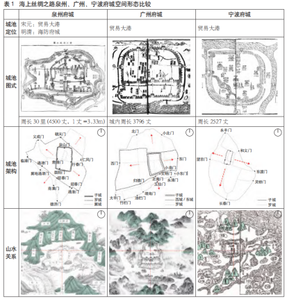
海上丝绸之路泉州、广州、宁波府城空间形态比较
在泉州府城与同为贸易大港的宁波府城、广州府城对比中:三者城池内的十字路网每段街道均跟随当地地貌扭曲,而泉州府城曲折段数最多;即使与广州府城扩张方式类似——初期以层状方式沿子城横向平行扩张后期再以纵向延展,泉州子城与外城在朝向上有偏差。
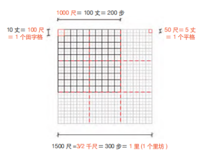
平格、百尺、千尺与里坊数理关系示意
在传统井田规划计量系统中,水平向计量单位主要通过步数将距离与人的移动行为相关联,而竖向则以丈、尺、寸将高度与人体尺度相关联。将“田”字格作为解读泉州古城传统民居组群外部空间组织规律的分析网格。

泉州古城传统民居组群外部空间千尺与百尺之间的“形势”交替密铺-东、西街平格、民国时期地图、卫星图叠图后“形势”组织关系(右图无叠加卫星图)
在线性序列关系上,北侧开元寺与泉州府组群相距1700尺,即相隔1个“里”加上1/3处占据200尺的子城城墙及其护城河,形成“形势”交替密铺关系;南侧由“百尺”的民居组群构成,由于观东巷在“里”的1/3处,构成与北侧局部错位交替密铺。
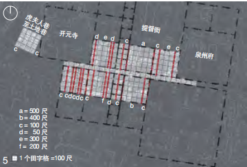
泉州古城东、西街“百尺”交替密铺
“百尺”内的巷道将民居组群界面分为100~500尺等5类宽度,将序列细分迭代,并在护城河两侧形成两组韵律各异但“积形成势”的民居组群。
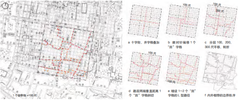
“边界”转折密铺组织方式
“坊”存在两种划分方式:内十字街将空间4等分及沿南北、东西方向3等分相叠加,形成4段内街、16段里巷基本构成关系。其次,4段内街各沿顺时针平移1个“田”字格,形成一重“边界”;再将16段里巷以转折、斜切、L型路径增设的方式建立多重边界。

泉州古城城池、承天寺定位关系示意
将“井”字格置于城池尺度,其主要以背山面水、山势4个象限对位为原则。泉州古城所选的位置被当地人称为“风水宝地”,自五代南唐修筑罗城后,即使历经宋、元、明亦未被攻陷过。泉州古城山势走向虽非为正南北,但符合山势对称构图。
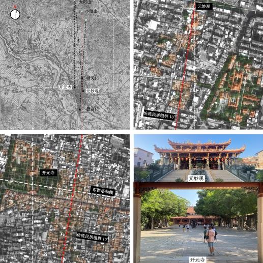
泉州古城的两条轴线
泉州古城存在两条交错的轴线,而其夹角关系至少构成古城两种“田”字网格,其交叠处产生的异形空间需通过人为营建以平衡8个方向的循环对位关系,如开元寺中正殿与东西塔的网格夹角,影响其内部附属建筑组群及外部民居组群的空间组织,呈现出层级迭代、分解空间的趋势。

Geometric form-based typologies in forming circular–radial space
The radial and the grid geometry are commonly used in urban form, and their diverse combinations at the neighborhood scale produce the basi typologies including axial pattern, concentric pattern, diagonal–grid pattern, and grid pattern.
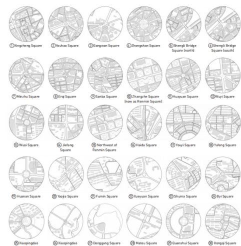
The 30 case sites of circular–radial space in Dalian
The study examined all the 30 case sites of circular–radial space in the core area of Dalian , of which case sites 10 and 28 have been demolished or converted, to explain their local adaptation since the introduction in the 1900s and to identify the morphological and functional changes they have undergone, in order to provide a viable path for urban renewal.
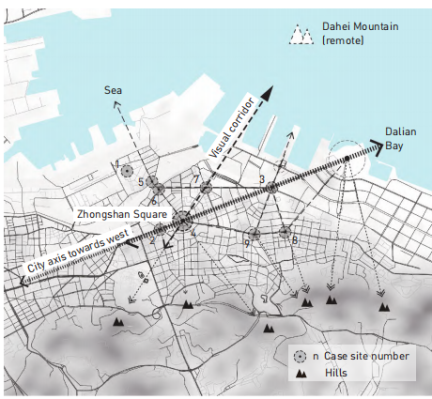
Diagram of landscape-oriented circular–radial spaces in Dalian
The Baroque axial system offered visual corridors directing to remote mountain, hills and the sea, which made circular–radial space landscape-oriented.
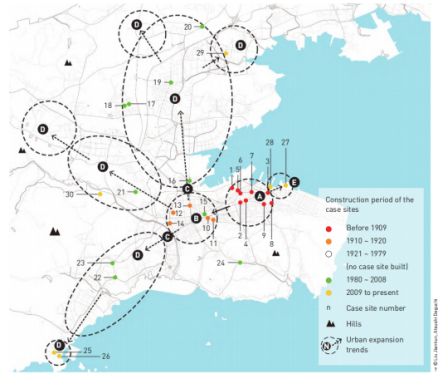
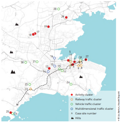
Distribution of the case sites of circular–radial space in Dalian
In the space dimension, when the distribution of case sites is compared to the process of urban expansion, they generally coincide at each stage.
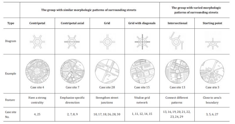
Morphological classification
The study divides the 30 case sites into two groups according to whether the streets around each case site have similar morphologies, and then subdivided into six types: centripetal, centripetal–axial, grid, grid with diagonals, intersectional, and starting-point.
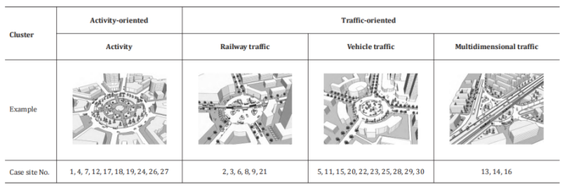
Functional classification
By recording whether there exist 13 physical elements in each case site, ranging from traffic, activity , and landscape , and conducting cluster analysis, they were categorized into two functional clusters, activity-oriented and traffic-oriented, with four sub-clusters, namely activity, railway traffic, vehicle traffic, and multidimensional traffic.
Distribution of the functional clusters of circular–radial space in Dalian
This figure displays that the case sites built in the early 20th century established visual corridors in-between and reinforced their sense of axis with ground trams in the Tsarist Russian planned area.
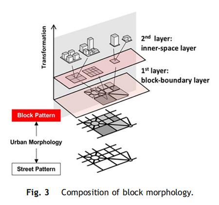
Composition of block morphology
Blocks in Beijing can be decomposed and divided into 2 layers.The first is the block-boundary layer, which is decided by the structural urban road network with high unchangeability. The second is the inner-space layer,.reflecting how they transformed inside, including the sub-division, buildings, etc.
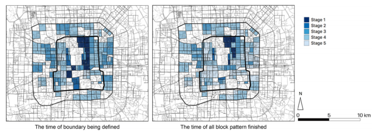
The time (corresponding urban development stages) of the block formation process.
The time of block boundary defining and the time of all patterns being finished were corresponded to each urban development stage based on historical maps.
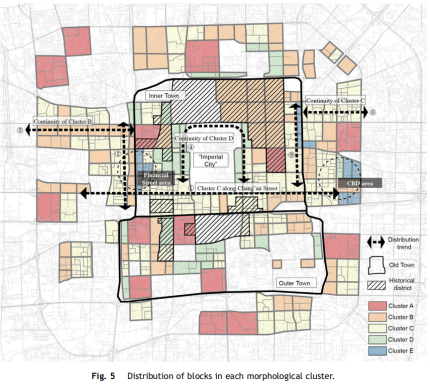
Distribution of blocks in each morphological cluster.
Taking the interface between the Inner Town and the Outer Town as a boundary line, the south part based on the original Outer Town shows almost no regularity.

Distribution of blocks based on size (left) and shape regularity (right).
The block sizes in Beijing are not unified at similar scale.When the blocks in super large size distribute randomly,the smaller-size ones are more likely to concentrate in limited areas along the ring roads and main streets.
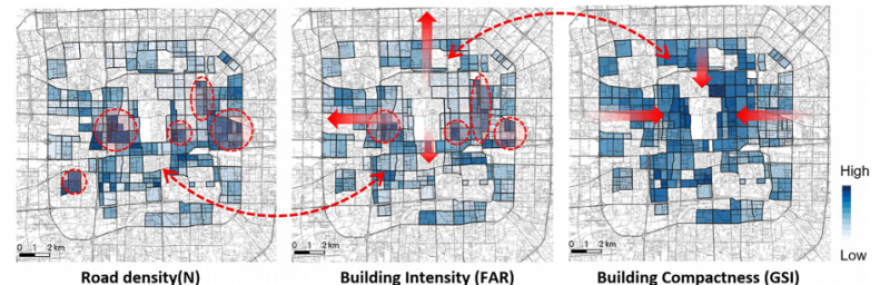
Distribution of blocks based on road network density, building intensity, and building compactness.
The road network density differs a lot in Beijing, especially the ones built in Stage 1 in the Old Town and the newly built ones in recent decades.The later ones adopt concentrated distribution in several regions.

Distribution of blocks in each subdivision pattern type.
Type 1 and Type 2 take up the main part of the Old Town in Beijing, especially inside the inner town. Type 1 (No-subdivision Type) accords mostly with historical districts, proving its common implementation as the traditional and distinctive pattern in the antiquity. While, Type 2 shows its advantages along main streets aiming to get higher accessibility, or to get continuous streetscapes.